PHOTOS: The lost village of Hazeldean

A child standing on what's now Hazeldean Road, east of Terry Fox. Photo from the collection of Roger Young.

All the strip malls and pavement make it hard to imagine today, but 50 years ago Hazeldean Road, all the way through Kanata South and into Stittsville, was lush green farmland.

The village of Hazeldean was situated at the crossroads of what’s now Hazeldean Road and Young Road. In the spring you would have seen rolling hills of green, cows and pigs alongside the road, children playing in the fields. There was a cheese factory, a brass band, a schoolhouse.

There are still a few hints of this history. There’s the gorgeous Sparks House that’s now “The Spa” on Castlefrank. There’s the Grierson Residence in front of the Goodlife on Hazeldean. Along Young Road you’ll find the old Masonic Hall and an old church, and there’s a hidden cemetery not far from the Tim Hortons on Edgewater – one of three cemeteries in the area.

Roger Young grew up in Hazeldean, and now calls Stittsville home. His family was one of the earlier 19th century settlers in the area and their name is still prominent: Young Road, Young’s Pond Park, John Young Elementary School.

“I was born in 1950 in Hazeldean and until the mid-60s it was almost as it had been at the turn of the century, if not longer,” he says. “One side of our farm is marked now by Terry Fox and the other by Young Road. I grew up there and knew all the elderly people and all the past residents of Hazeldean. I photographed the entire community before any of the housing was built. The original settlers came to Canada with the Talbot group in 1818 on the Brunswick and we would be the last family remaining.”

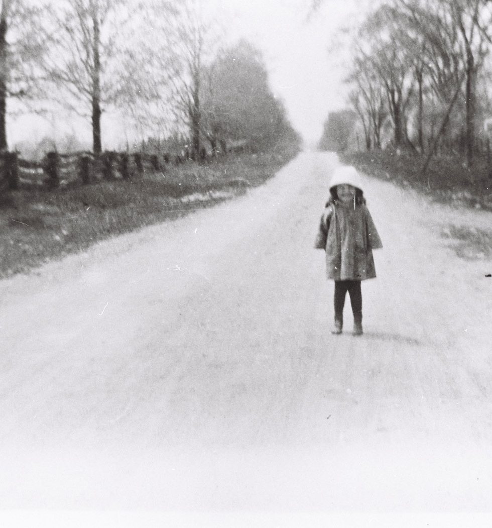
Over the past few months Roger has been kind enough to share some photos from his family’s collection. Many of the colour photos were taken by Roger himself when he was a young man in the 1960s. Most of them show scenes from along Hazeldean Road and Young Road. He’s been collecting and organizing them as part of a family history project.

The 1960s photos were taken just before the area started its transformation into a suburban community, with the development of Glen Cairn and later Katimavik. They provide a fascinating view into into the history of our community.

I’d like to thank Roger for his generous hospitality, and the time he’s spent to meet with me and share his photos and fond memories of the old village.

(Click on any photo to view larger size.)

Hazeldean in 1965. Photo from the collection of Roger Young.
Hazeldean in 1965.
Photo from the collection of Roger Young.


Hazeldean in 1965. The barns belong to the Griersons and Sparks on the south side of Hazeldean Road. Photo from the collection of Roger Young.


Hazeldean in 1965. Photo from the collection of Roger Young.
Hazeldean in 1965.
Photo from the collection of Roger Young.


Hazeldean in 1965. Photo from the collection of Roger Young.
Hazeldean in 1965. This is now the strip mall with the Starbucks and Goodlife. Photo from the collection of Roger Young.


Hazeldean in 1965. Photo from the collection of Roger Young.
Hazeldean in 1965.
Photo from the collection of Roger Young.


Hazeldean in 1965. Photo from the collection of Roger Young.
Hazeldean in 1965.
Photo from the collection of Roger Young.


Hazeldean in 1965.
Photo from the collection of Roger Young.


Hazeldean in 1965. Photo from the collection of Roger Young.
Hazeldean in 1965.
Photo from the collection of Roger Young.


Hazeldean in 1965. Photo from the collection of Roger Young.
Hazeldean in 1965.
Photo from the collection of Roger Young.


Detail from the map of Goulbourn Township from the Belden Atlas, 1879. The thick horizontal line in the middle of the map is Hazeldean Road, and the churches are clustered along what's now Young Road in Kanata. The small squares represent homes in the area. The rail line at the bottom is now the Trans Canada Trail.
Detail from the map of Goulbourn Township from the Belden Atlas, 1879. The thick horizontal line in the middle of the map is Hazeldean Road, and the churches are clustered along what’s now Young Road in Kanata. The small squares represent homes in the area. The rail line at the bottom is now the Trans Canada Trail.


A child standing on what's now Hazeldean Road, east of Terry Fox. Photo from the collection of Roger Young.
A child standing on what’s now Hazeldean Road, east of Terry Fox.
Photo from the collection of Roger Young.


Hazeldean was (and still is) a hilly place and toboganning was a favourite winter activity. Photo from the collection of Roger Young.


Old barn. Photo from the collection of Roger Young.


Looking towards St. Paul's Church, from a vantage point where the Kanata Rec Centre is now located on Terry Fox. The house on the hill is the Young farm. The original community churches are also visible, along with the Masonic Hall. The first church, cemetery, and Masonic Hall are still there. Photo from the collection of Roger Young.
Looking towards St. Paul’s Church, from a vantage point where the Kanata Rec Centre is now located on Terry Fox. The house on the hill is the Young farm. The original community churches are also visible, along with the Masonic Hall. The first church, cemetery, and Masonic Hall are still there. Photo from the collection of Roger Young.


The Hazeldean Band, circa 1887. Photo from the Goulbourn Township Historical Society archives.
The old Groceteria / general store. Young's father purchased the store in 1956. Photo from the collection of Roger Young.
Young’s Groceteria, the old general store.  Note the fuel pumps out front. Young’s father purchased the store in 1956. Photo from the collection of Roger Young.


The original St. Paul's Church. Photo from the collection of Roger Young.
The original St. Paul’s Church. Photo from the collection of Roger Young.


The Hazeldean Cheese Factory. All of Goulbourn Township was highly regarded for the quality of its dairy products. Photo from the collection of Roger Young.


The old school house, SS#13 Goulbourn. Built in 1872, this photo was taken around 1900. Photo from the collection of Roger Young.
SHARE THIS